

Cloverley school traffic safety plan scaled back
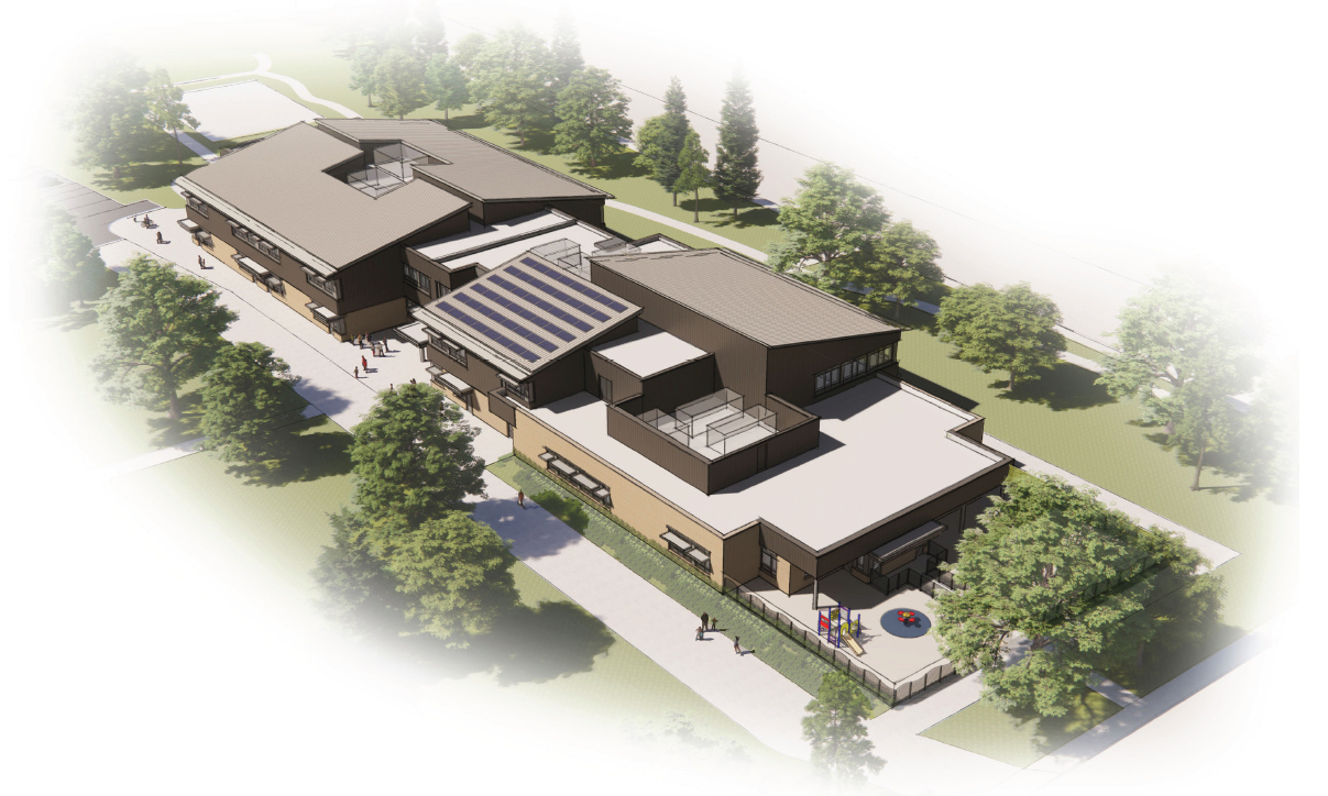
The new Cloverley school is opening in September. Image source.
Cloverley school closed in 1982. That’s more than 40 years ago. People living in the neighbourhood now could have been there for two entire generations and never experienced what traffic would be like when the school was in operation. That’s going to change, big time. It won’t be easy.
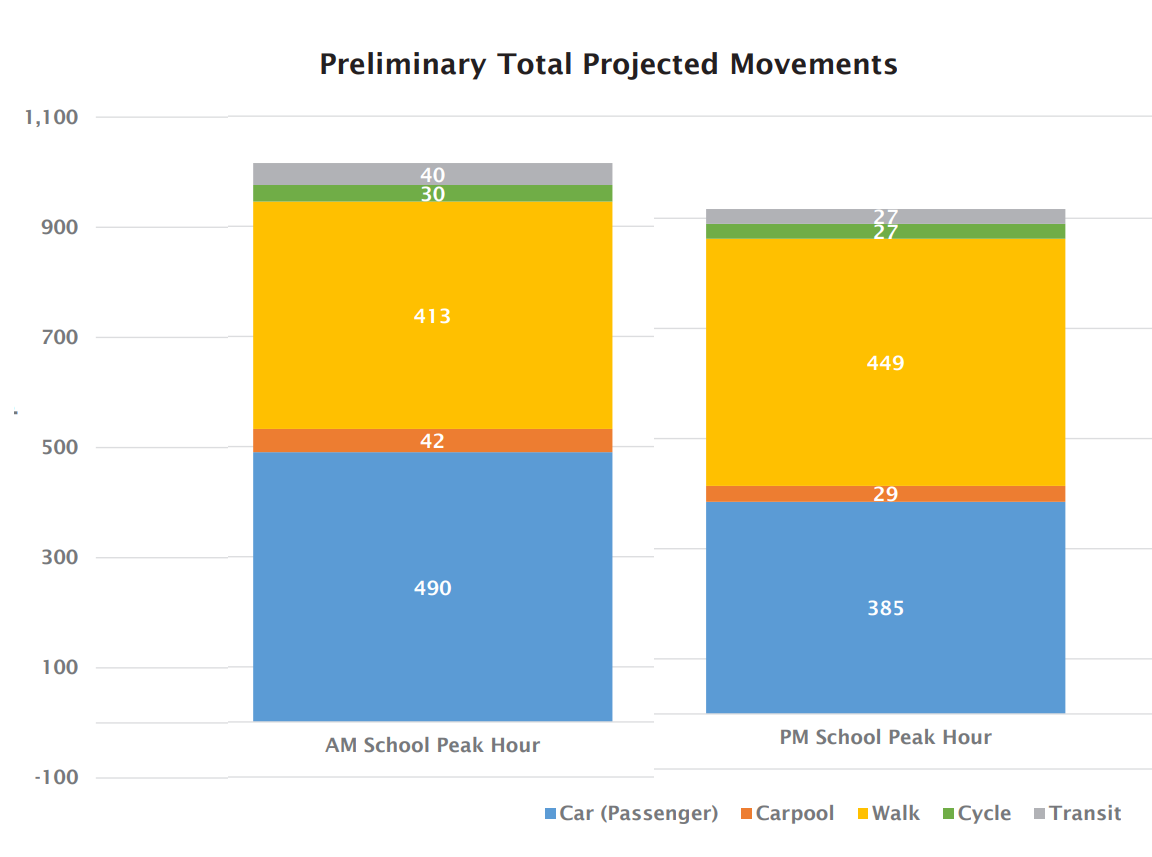
Forty years ago, kids mostly walked to school. Now the estimate is that almost 500 cars in the morning and 400 in the afternoon will drop them off and pick them up.
The Cloverley neighbourhood has struggled with traffic back-ups from the bridge for years. Both Shavington and Cloverley are popular rat-running routes, and residents have been vocal about stopping the practice. The City did try to fix the problem. They tried one-way streets. Right-turn restrictions. Pilot projects were started, then reversed due to feedback. Council repeatedly apologized to residents. Basically, until the causal problem of bridge back-ups is resolved, traffic will shift to adjacent streets, no matter what we do.
And now that area will be a school zone?
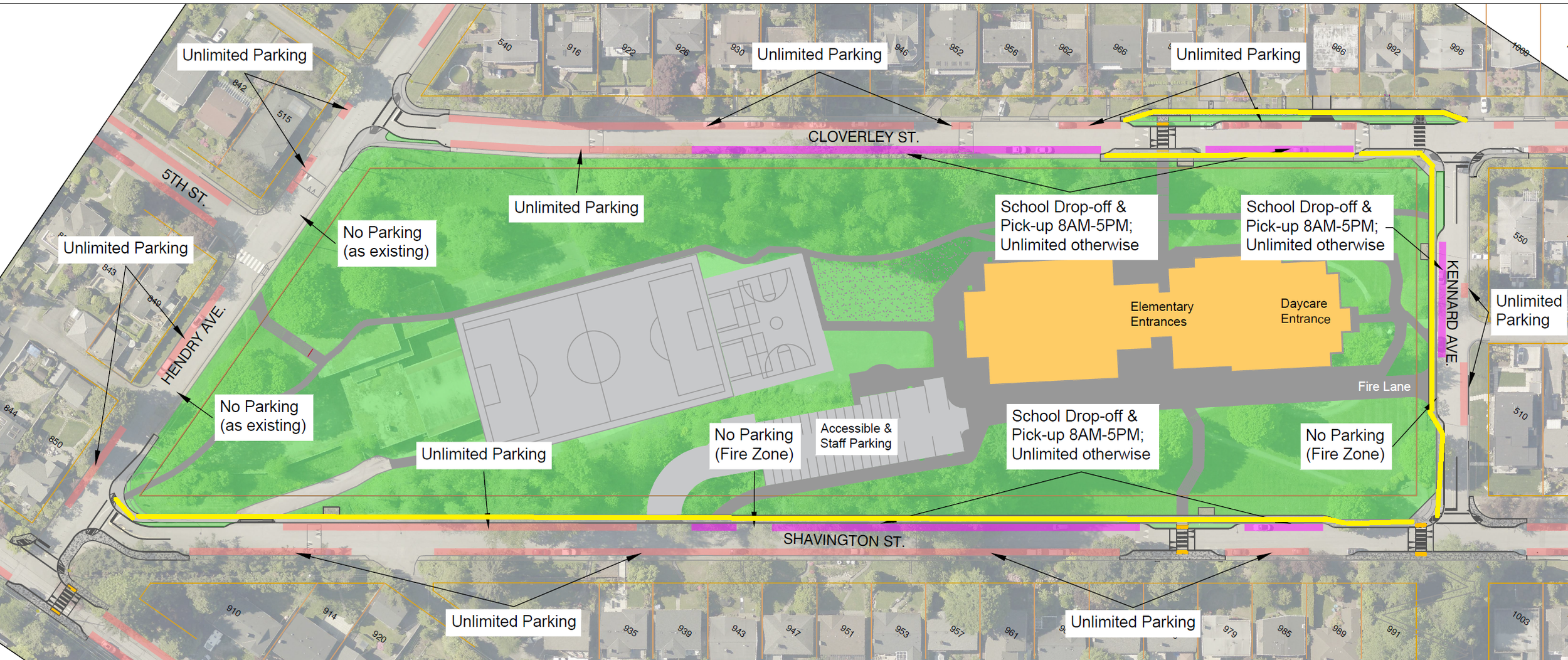
The school is set to open in September, so we are getting down to the details of how to get kids there. The original city traffic management plan for the immediate school area, along all four adjacent streets, would widen existing sidewalks to meet the city standard and create new ones where none currently exist. In addition, the plan included broad curb bulges at all crosswalks and street lighting around the school, especially important now that permanent daylight time means children will arrive at school in the dark during winter. The wider sidewalks would also narrow the streets, potentially reducing vehicle speeds.
Here’s what that original plan looked like with wide sidewalk locations indicated in yellow:
The yellow lines show where the original plan would create wide sidewalks. Image source: modified from the staff report
It’s kind of hard to tell what the sidewalks would be like from a schematic, so here’s a screengrab from Google showing the new wider sidewalk and green space around it at the new Argyle school.
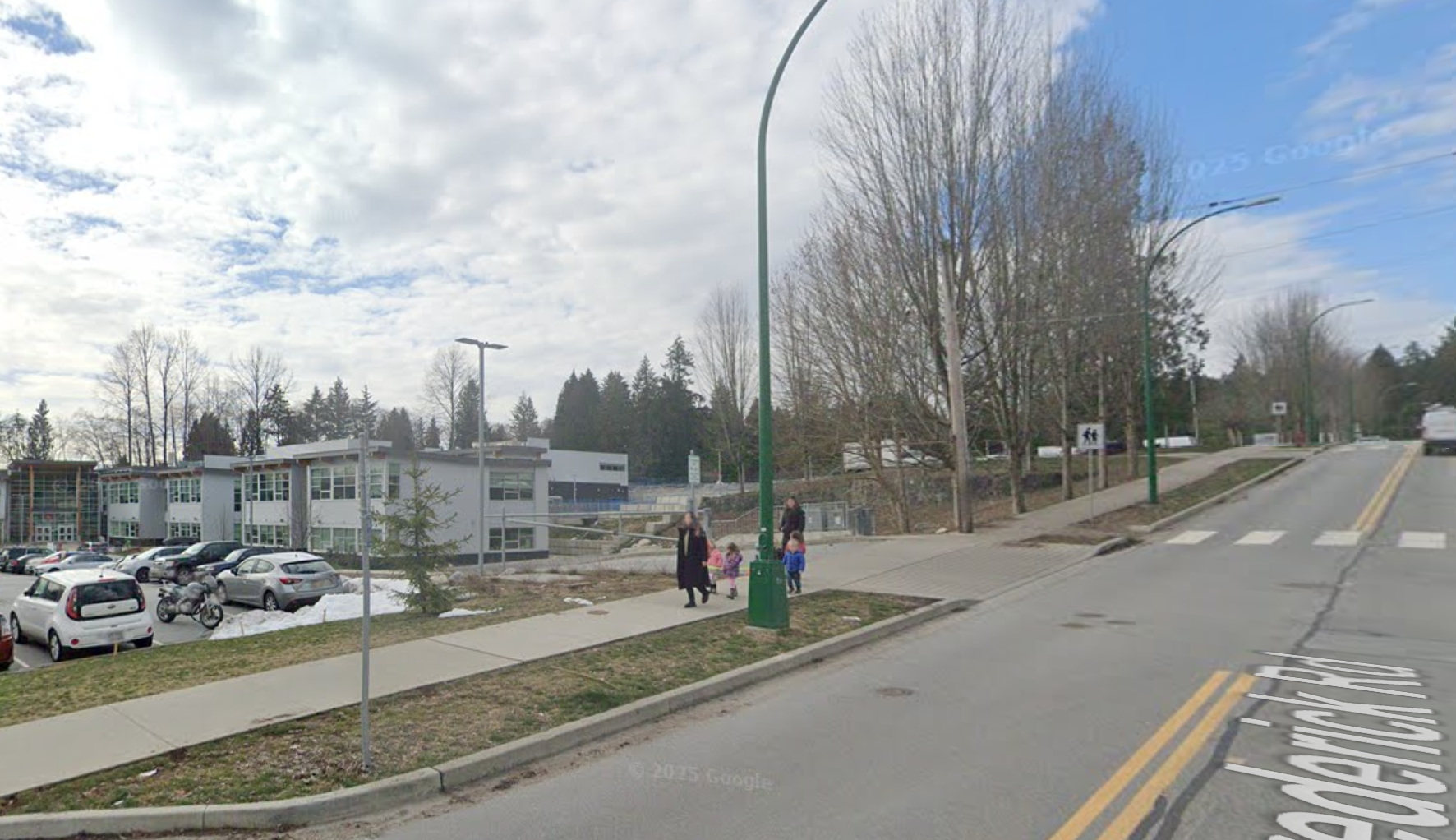
This sidewalk alongside Argyle school looks safe and more appealing. If we want kids to walk, we need the kind you see above. Image source: Google maps
Residents in the immediate neighbourhood of the school will be heavily impacted by the twice-daily rush of vehicles.
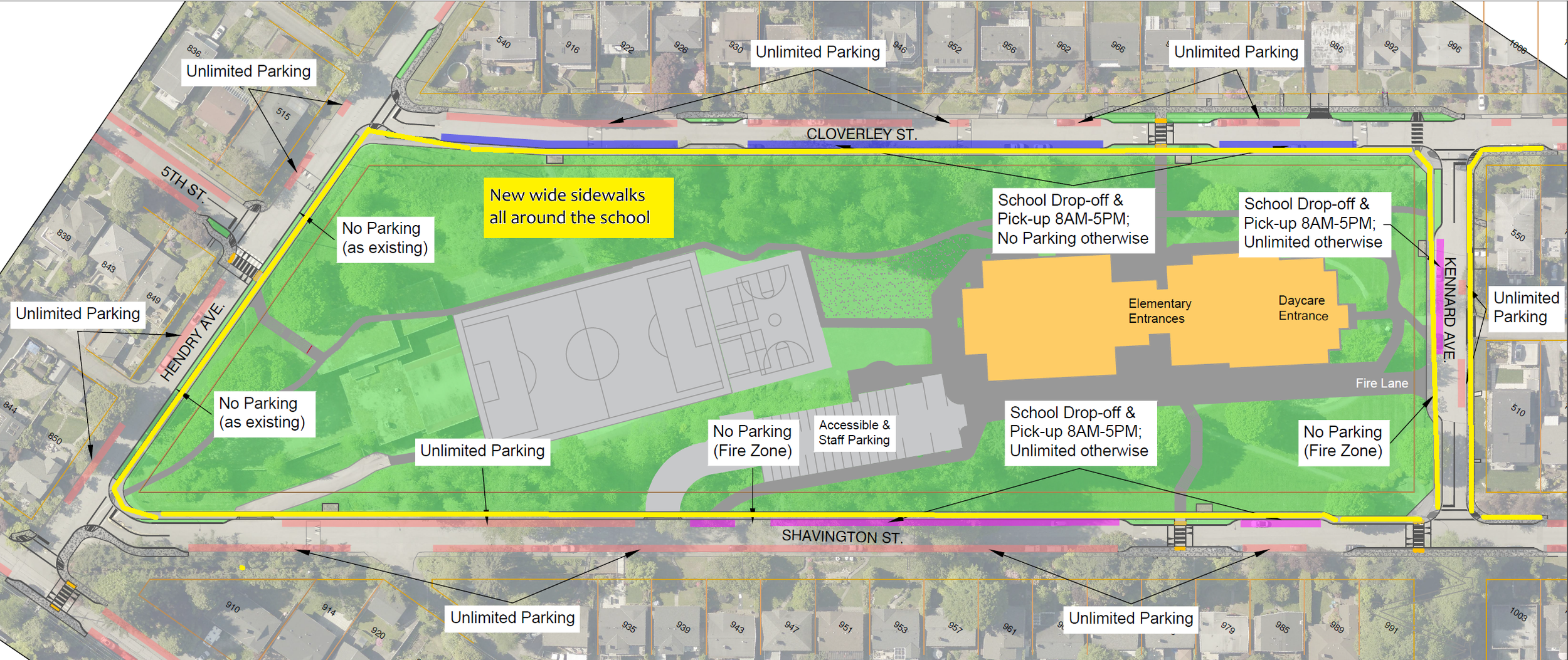
This area is currently quiet, with only intermittent horrendous bridge traffic. It’s not just the noise and traffic that will change the neighbourhood. The city’s original plan called for removing parking along both Shavington and Cloverley to make room for a wider sidewalk for pedestrians. But that plan has been altered now due to resident pushback.
Although all the houses have lane access, people have gotten used to parking close to their front doors, and some may have accessibility challenges that make it hard to access their houses from a steep hill. People may also have made construction and property-use decisions based on the availability of on-street parking. Now, that’s about to change after forty years.
It’s a tough one for sure. To address resident complaints about the removal of parking and changes to the boulevard, the city is proposing a compromise that eliminates most of the new, wide sidewalk along Hendry and Cloverley, as well as the proposed sidewalk on the east side of Kennard.
The yellow line indicates where wide sidewalks remain in the modified plan, Parking along Cloverley has been restored. Image source: modified from the staff report
Remember the screengrab of the nice sidewalk along Argyle school? Only some of the sidewalks will look like that. The others will look like this, one of the existing ones on Cloverley.

These narrow sidewalks on Cloverley, directly beside the street with no buffer, will remain. photo: Heather Drugge
More great safety features
The city's plan includes new raised crosswalks with curb bulges at the main entrances on both Shavington and Cloverley. Because the lot is long, additional crosswalks make sense because kids will be tempted to cross ‘wherever’. Crossing ‘wherever’ might work now, with very little traffic, except during bridge back-ups. But it won’t be remotely safe with hundreds of cars circulating.
To ensure people driving can see pedestrians, the city will add curb bulges that remove parking adjacent to all crosswalks. That’s great, because not only do curb bulges decrease the amount of time a child is on the road while crossing, but they also slow down drivers and increase pedestrian visibility. I suggest another mid-block raised crosswalk with curb bulges on Shavington, which is a long street. Kids might be tempted to cross without protection to get to the playing fields above.
Here’s where the curb bulges and crosswalks will be added:
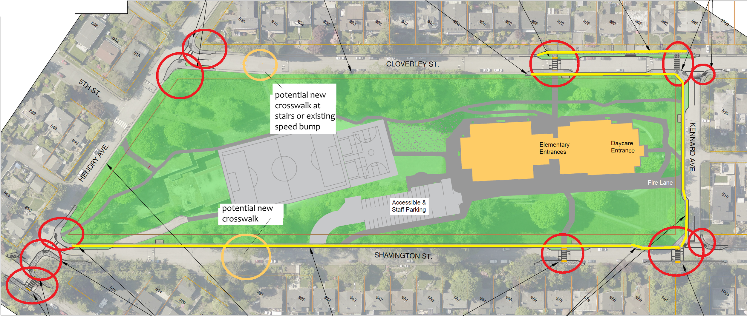
I’ve highlighted the new curb bump-outs and crosswalks in red. In light orange, I’m indicating where it would be good to include a couple more. It would be better to raise all the crossings, but only the ones at the main entrances and at the Kennard Greenway connection will be. The one on 4th at Hendry is already raised. Image source: modified from the staff report
Voluntary one-way ‘advisory’ loop?
Even before the first iteration of the city’s traffic management plan, in 2024, the School District created a mobility plan that showed a one-way advisory loop. The loop is clockwise, because it makes sense to drop kids off on the right-hand side of the street: they don’t have to cross the street to get to the school. The word ‘advisory’ means the city wouldn’t enforce the one-way with barriers, bollards, or one-way signs. It’s a ‘recommended’ pattern that relies on drivers voluntarily following it. Or on crossing guards to direct traffic. I haven’t seen this crop up in any of the city documents, but it could come later since it does not require actual roadwork. This is a good idea, primarily dependent on training drivers.
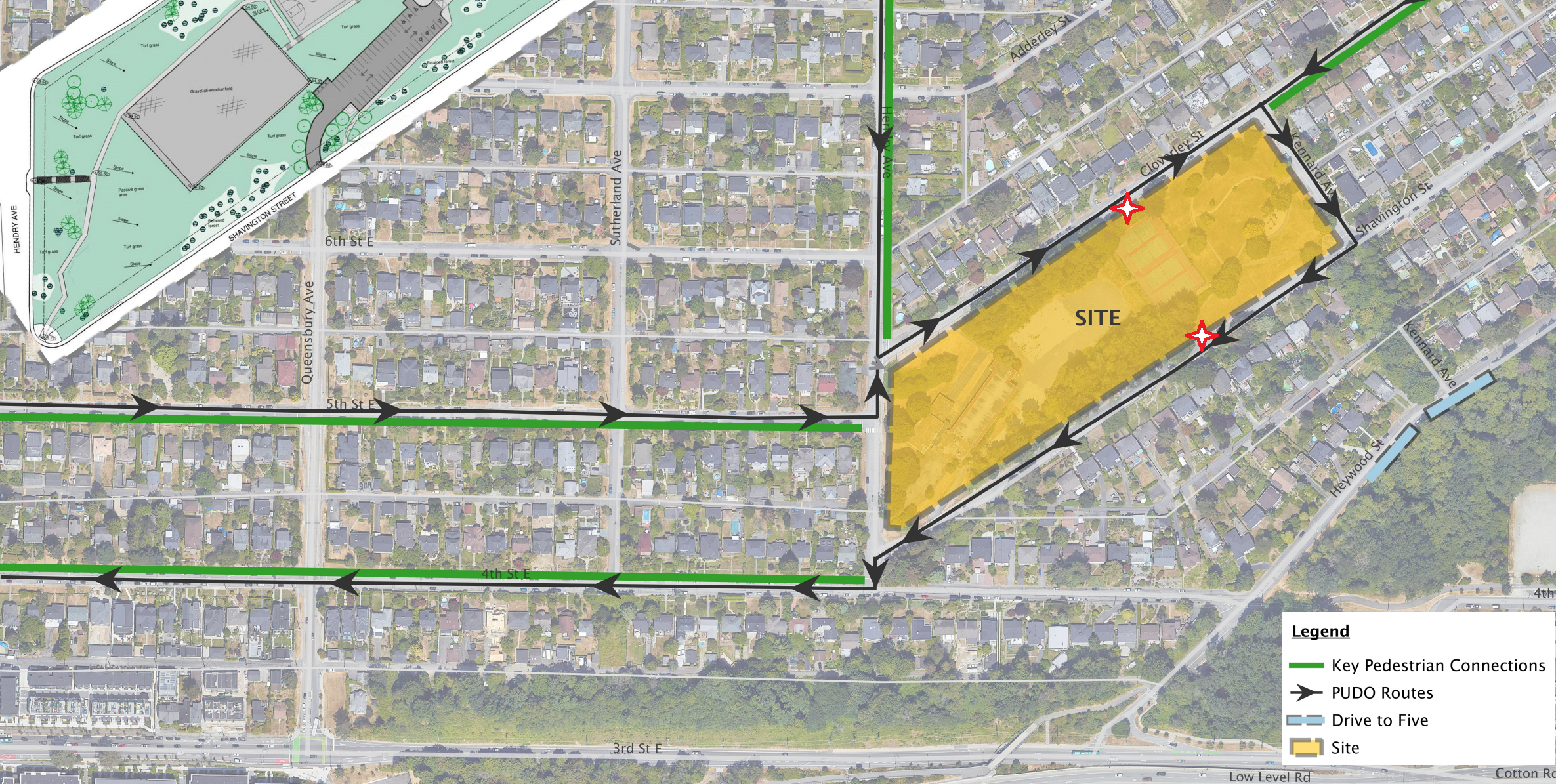
Route of the one way advisory loop. Image source.
Maybe we should rethink the sidewalks
While schools in Vancouver are literally closing streets along schools to traffic, we are trying to figure out how to keep all traffic moving in both directions and preserve most of the existing parking. Plus, we’re cancelling a large portion of the broad sidewalk that would help kids walk alongside a steep hillside with either moving or parked cars beside them.
What’s more important?
The school will serve 500+ students per year. Presumably for many years to come. How should the city prioritize the use of public property near the school? Whatever we build has to be safe. Wide sidewalks, crosswalks, curb bulges, traffic calming and street lighting are essential to our children’s safety. Parking is not.
Council still has time to restore the original plan before September. If you’re concerned about the new plan, please write to the City of North Vancouver council before the meeting on Monday. Let them know you think sidewalks are important. Contact all members of Council and the Mayor by email at CityCouncil@cnv.org.
If this story resonates with you, please forward this to a few friends and suggest they join our email list. We're building a group of like-minded people who want to see the North Shore positively embrace and manage the many changes we face. Thanks, we really appreciate it.